2. 国家海洋局南海环境监测中心,广东广州 510300
2. South China Sea Environment Monitoring Center, State Oceanic Administration, Guangzhou, Guangdong, 510300, China
【研究意义】南海是邻近中国大陆最大的半封闭深水海盆,海岸线和海底地形非常复杂。在季风、太阳辐射、地形和周边海域水交换等因素的共同作用下,南海海流运动特征也变得较为复杂。【前人研究进展】国内外已有很多海洋学者对南海海流运动进行相关研究,其主要研究手段以数值模拟为主[1-7],或者以海洋浮标观测数据进行分析得到[8-9];苏京志等[10]利用1988—1998年间26个浮标资料,分析了南海部分海域的表层流场,给出了0.5°×0.5°网格的平均海流矢量图;方文东等[11]对南海上层环流研究做了详尽评述。采用数值模拟方法研究存在着一些局限性,例如采用数值模拟方法计算地转流时零势面的选取、数值模式的边界条件、初始条件的确定都影响到反演出流场的准确性[12]。【本研究切入点】在前人研究的基础上[13-15],利用2017年6月在南海北部海南岛东北海域大潮期9个连续周日海流观测资料,对研究区域海流随时间、深度的变化及各个分潮的特点进行研究。【拟解决的关键问题】通过准调和分析获得各分潮流的调和常数和椭圆要素,进而讨论该海区的潮流性质、潮流运动形式、M2分潮椭圆要素以及夏季的余流分布,从中试图了解调查海域的潮流和余流特征及分布规律,以期为进一步研究南海海流提供参考。
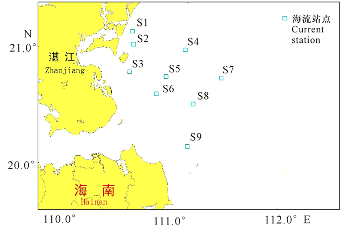
1 材料与方法 1.1 材料本研究采用的实测海流数据主要来源于2017年6月实测的大潮周日海流观测数据,观测站点9个,站号为S1~S9(图 1)。大潮观测采用准同步测量,S1~S4测站调查时间为2017年6月10日09:00—2017年6月11日10:00,S5~S9测站调查时间为2017年6月08日23:00—2017年6月10日00:00,各站点的站号、分布区域见图 1。

|
图 1 海流站点分布 Fig.1 Distribution map of current stations |
采用引入差比数的方法,对2017年6月实测的大潮期海流资料进行准调和分析,计算出主要分潮流的调和常数、椭圆要素和观测期间的余流。
应用差比关系的方法计算M2、S2、O1、K1、M4、MS4等6个分潮的潮流调和常数;这些要素决定并反映了分潮流的基本特征。
潮流的性质也称潮流的类型,它主要是根据全日、半日分潮流的相对比率来划分的。根据我国《港口工程技术规范》的规定[16],采用
正规半日潮流:
不正规半日潮流:
不正规全日潮流:
正规全日潮流:
式中,WO1, WK1, WM2分别为O1, K1, M2分潮流的椭圆长轴。
2 结果与分析 2.1 潮流性质大潮期各站层的潮流性质系数F值见表 1。由表 1可看出,9个站点各层的F值为0.36~1.80,调查海区的潮流主要为不正规半日潮流。F值的最小值出现在S2站表层,最大值出现在S4站底层。其中,S4站日潮成分最大,S3站次之。
| 表 1 海流特征参数 Table 1 Characteristic parameters of current |
根据调和分析结果,计算主要分潮流的椭圆要素,其中M2分潮潮流椭圆参数值见表 1。可以看到,S5、S6和S9站潮流较强,S2、S3、S7和S8站次之,S1和S4站较弱;除S3和S8站以外,其余各站各层分潮椭圆长半轴方向基本一致,潮波从东南向西北传播。M2分潮流的椭圆旋转率绝对值为0.01~0.47,S7、S8和S9站的旋转流较为明显。
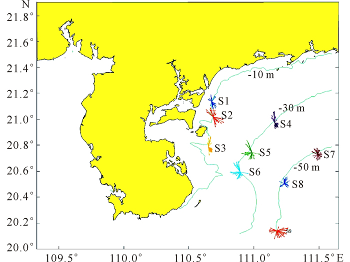
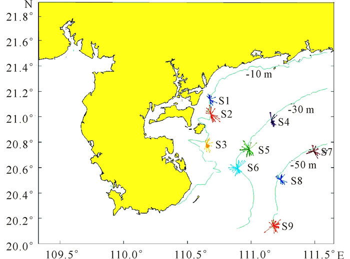
2.2 潮流运动形式海流观测的统计结果显示(表 2):各层海流流速大小相当,各层流向基本一致,近岸海流流速较小,从近岸向外海海流逐渐增强;潮波传播类型主要以前进波为主,传播方向大致为垂直于等深线的方向;其中S4站海流以往复流为主,往复流的方向为NW—SE;除S4站以外,其余各站海流均为略带旋转的往复流,往复流的方向为NW—SE,旋转流的旋转方向为顺时针,各站海流玫瑰图见图 2~4。
| 表 2 海流特征值统计 Table 2 Current eigenvalue statistics |

|
图 2 表层海流矢量玫瑰图 Fig.2 Surface current vector rose diagram |

|
图 3 中层海流矢量玫瑰图 Fig.3 Middle current vector rose diagram |

|
图 4 底层海流矢量玫瑰图 Fig.4 Bottom current vector rose diagram |
余流分析结果表明(表 3),南海北部海南岛东北海域表层余流大于中底层,近岸余流较弱,琼州海峡附近的站点余流最强;各站表、中、底层余流流向较一致,表层余流主要受风场的影响作用,底层余流主要受到底地形的影响。大潮观测期间余流最大值为0.13 m/s,位于海南岛东北部的S9站点,最小值为0.01 m/s,位于广州湾出口的S1站,该海域表层余流主要为偏西北向,中、底层的流向依次增大,与风海流的下层运动规律相反,受风应力传递时间滞后影响,下层风海流流向逐渐右偏即流向增大。
| 表 3 各站位余流统计 Table 3 Statistics of residual current at various stations |
通过对2017年6月在海南岛东北海域调查的9个连续周日海流观测资料进行分析研究,主要得到以下结论:
研究海域的潮流以不正规半日潮流为主;研究海域各站点潮流椭圆旋转率都较小,其中S4站海流以往复流为主,往复流的方向为NW—SE;除S4站以外,其余各站海流均为略带旋转的往复流,往复流的方向为NW—SE,旋转流的旋转方向为顺时针;海南岛东北海域潮流的垂向变化均不大,随着水深的增加,潮流的椭圆旋转率增大,最大流速略减;海南岛东北海域表层余流大于中底层,近岸余流较弱,琼州海峡附近的站点余流最强;各站表、中、底层余流流向较一致,表层余流主要受风场的影响作用,底层余流主要受到底地形的影响。
| [1] |
蔡树群, 苏纪兰. 南海环流的一个两层模式[J]. 海洋学报, 1995, 17(2): 12-20. CAI S Q, SU J L. A two-tier model of circulation in the South China Sea[J]. Acta Oceanologica Sinica, 1995, 17(2): 12-20. DOI:10.3321/j.issn:0253-4193.1995.02.008 |
| [2] |
METZGER E J, HURLBURT H E. Coupled dynamics of the South China Sea, the Sulu Sea, and the Pacific Ocean[J]. Journal of Geophysical Research, 1996, 101(C5): 12331-12352. |
| [3] |
TAKANO K, HARASHIMA A, NAMBA T. A numerical simulation of the circulation in the South China Sea-Preliminary results[J]. Acta Oceanographica Taiwanica, 1998, 37(2): 165-186. |
| [4] |
CAI S Q, SU J L, GAN Z J, et al. The numerical study of the South China Sea upper circulation characteristics and its dynamic mechanism, in winter[J]. Continental Shelf Research, 2002, 22(15): 2247-2264. DOI:10.1016/S0278-4343(02)00073-0 |
| [5] |
YUAN Y C, LIU Y G, LIAO G H, et al. Calculation of circulation in the South China Sea during the summer of 2000 by the modified inverse method[J]. Acta Oceanologica Sinica, 2005, 24(1): 14-30. |
| [6] |
WANG H Q, YUAN Y C, GUAN W B, et al. Circulation in the South China Sea during summer 2000 as obtained from observations and a generalized topography-following ocean model[J]. Journal of Geophysical Research C:Oceans, 2004, 109(7): 1-12. |
| [7] |
陈波, 邱绍芳, 葛文标, 等. 广西沿岸主要海湾潮流的数值计算[J]. 广西科学, 2001, 8(4): 295-300. CHEN B, QIU S F, GE W B, et al. Numerical calculation about the tidal currents in the main bays of Guangxi[J]. Guangxi Sciences, 2001, 8(4): 295-300. DOI:10.3969/j.issn.1005-9164.2001.04.015 |
| [8] |
朱晓婷, 陈学恩. 南海西部海流和温度长期定点观测分析[J]. 中国海洋大学学报, 2014, 44(4): 15-21. ZHU X T, CHEN X E. Analysis of temperature and currents long-term obervations in the western South China Sea[J]. Periodical of Ocean University of China, 2014, 44(4): 15-21. |
| [9] |
陈波, 侍茂崇, 郭佩芳, 等. 北部湾北部潮流谱分析和余流特征研究[J]. 广西科学, 2014, 21(1): 54-63. CHEN B, SHI M C, GUO P F, et al. Analysis of tidal current spectrum and study of residual current in northern Beibu Gulf[J]. Guangxi Sciences, 2014, 21(1): 54-63. |
| [10] |
苏京志, 卢筠, 侯一筠, 等. 南海表层流场的卫星跟踪浮标观测结果分析[J]. 海洋与湖沼, 2002, 33(2): 121-127. SU J Z, LU J, HOU Y J, et al. Analysis of satellite-tracked drifting buoys in the South China Sea[J]. Oceanologia et Limnologia Sinica, 2002, 33(2): 121-127. DOI:10.3321/j.issn:0029-814X.2002.02.002 |
| [11] |
方文东, 方国洪. 南海南部海洋环流研究的新进展[J]. 地球科学进展, 1998, 13(2): 166-172. FANG W D, FANG G H. The recent progress in the study of the Southern South China Sea circulation[J]. Advance in Earth Sciences, 1998, 13(2): 166-172. DOI:10.3321/j.issn:1001-8166.1998.02.011 |
| [12] |
杨庆轩, 梁鑫峰, 田纪伟, 等. 南海北部海流观测结果及其谱分析[J]. 海洋与湖沼, 2008, 39(6): 561-566. YANG Q X, LIANG X F, TIAN J W, et al. Observation on the current in the northern South China Sea and spectrum analysis[J]. Oceanologia et Limnologia Sinica, 2008, 39(6): 561-566. DOI:10.3321/j.issn:0029-814X.2008.06.004 |
| [13] |
中华人民共和国交通部. 港口工程技术规范:上[M]. 北京: 人民交通出版社, 1988. Ministry. Technical specification for port engineering:Vol[M]. Beijing: People's Communications Press, 1988. |
| [14] |
袁耀初, 赵进平, 王惠群, 等. 南海东北部450 m以浅水层与深层海流观测结果及其谱分析[J]. 中国科学:D辑, 2002, 32(2): 163-176. YUAN Y C, ZHAO J P, WANG H Q, et al. The observation results and spectral analysis of shallow water layer and deep ocean current in 450 m northeast China Sea[J]. Science in China:Series D, 2002, 32(2): 163-176. |
| [15] |
陈波, 邱绍芳, 葛文标. 广西沿岸主要海湾余流场的数值模拟[J]. 广西科学, 2001, 8(3): 227-231. CHEN B, QIU S F, GE W B. Numerical simulation of residual current field of key bays along the coast of Guangxi[J]. Guangxi Sciences, 2001, 8(3): 227-231. DOI:10.3969/j.issn.1005-9164.2001.03.020 |
| [16] |
方文东, 郭忠信, 黄羽庭. 南海南部海区的环流观测研究[J]. 科学通报, 1997, 42(21): 2264-2271. FANG W D, GUO Z X, HUANG Y T. Study on the circulation of the southern sea area in the South China Sea[J]. Chinese Science Bulletin, 1997, 42(21): 2264-2271. |
 2018, Vol. 25


